Recharge Enhancement of Groundwater in Rusk County
In Rusk County, the Carrizo-Wilcox recharges through its outcrop areas. Due to excellent aquifer characteristics, the recharge that occurs in Rusk County contributes significantly to the availability of Carrizo-Wilcox groundwater throughout much of the region.
Groundwater movement in the different aquifers within Rusk County is from points of recharge in aquifer outcrop areas to points of discharge.
In aquifer outcrops, groundwater movement is primarily downdip towards points of discharge, either along creeks, rivers, and streams or areas of significant groundwater production or withdrawal.
The annual estimated amount of recharge from precipitation values for Rusk County, as documented by the Texas Water Development Board GMA Run 14-011, shows an estimated 70,358 acre-feet per year for the Carrizo-Wilcox Aquifer and 1,200 acre-feet per year for the Queen City Aquifer.
Information on the geologic units and their water-bearing properties within Rusk County is available in the District’s Management Plan, located in the District Documents section of the District’s website.
Helpful Links
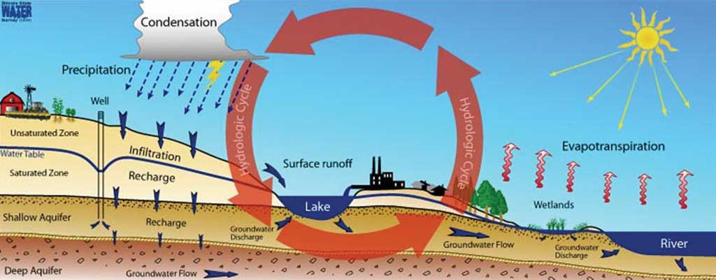
“The hydrologic cycle has a major impact on groundwater storage. Precipitation and surface water slowly move below ground until they are intercepted by plant roots or stopped by an impervious layer of material such as clay or shale. This process of downward migration is called groundwater recharge or percolation.
Groundwater recharge is an important natural process for replenishing groundwater supplies. In some areas of the world, however, drought and overuse of groundwater for urban and rural uses have led to alarming declines.
Coupled with these conditions is ongoing urban sprawl, which effectively seals potential recharge zones with paved streets, sidewalks, and rooftops. Reduced recharge rates in developed areas can cause downstream flooding problems as a result of increased surface runoff.
Preservation of wetlands along streams, stormwater detention ponds, and open space such as parks, golf courses, and wildlife areas can help preserve groundwater recharge zones.”
Thomas V Cech
Principles of Water Resources, History, Development, Management, and Policy: John Wiley & Sons, Inc., 2005